


-
Car,Bike
-
3 Stars Hotels
-
3,500 meters
-
Chandigarh
-
May, June, July, August, September
-
Self Drive
-
Dinner & Breakfast
-
English, Hindi
-
Easy to Moderate
-
15-25
-
8
-
65
Overview
Ladakh is one of the most thrilling and hilly tourist destinations of North India. Ladakh is located in the territory of the state of Jammu and Kashmir, which lies between Kunlun and the Himalayan mountain range in the south. The people settled in Ladakh are Tibetans and Aryans. The region is also called Little Tibet, as most people follow Tibetan culture.
Leh is the largest city and capital of Ladakh. The famous Leh Palace was built in 1553 by the Buddhist Empire. Years ago it was a stop for businessmen to travel to Central Asia, now the province is famous for tourists from India as well as around the world. Ladakh is made in two parts: Kargil and Leh, now Leh is synonymous with Ladakh.
Ladakh surrounded by magnificent land, huge snow-capped mountains, valleys, glaciers, amazing natural lakes, monasteries for natural leisure, adventure, photography, trekking, mountaineering, mortaring, spiritual, culture and traditions.
The main tourist places and cities of the region are Khardungla, Suru and Zanskar, Dzongkhul, Suru Valley, Rangadum, Sanku, Phugthal, Nubra Valley, Leh Gompa, Dras, Kargil, Indus Valley, Basgo and many more. See tour itinerary with package directions. The suggested tour can be customized to your needs.
Highlights
- Get ready to go on an adventure on your Car & Bike , starting from the beautiful valleys of Himachal, all the way to thrilling Ladakhi roads.
- Dive in the vibrant culture of Leh, exploring its bustling markets, ancient monasteries, and charming alleyways, while soaking in the majestic views of the surrounding mountains.
- Visit Pangong lake; the world’s highest saltwater lake that changes its color from shades of blue to green to red.
- Let the adrenaline rush pump through your veins as you drive through the world’s highest motorable passes like Khardung la and Lachung la.
Itinerary
Your journey from Chandigarh to Jispa via the Atal Tunnel is a scenic and exciting ride through the majestic Himalayas. Here’s a detailed guide:
Step 1: Arrival in Chandigarh
-
Chandigarh Airport (IXC) or Chandigarh Railway Station serves as the main arrival points.
-
Taxis, rental cars, and own car are available for the onward journey.
Step 2: Chandigarh to Jispa – Route & Distance
-
Total Distance: 480 km
-
Travel Time: 12 to 14 hours
-
Route: Chandigarh → Manali → Atal Tunnel → Keylong → Jispa
Road Conditions & Travel Breakdown
-
Chandigarh to Manali (300 km, 7-8 hours)
-
Mostly well-paved roads via NH3.
-
Scenic drive through Bilaspur, Mandi, and Kullu.
-
Alternative Stop: Overnight stay in Manali if needed.
-
-
Manali to Jispa via Atal Tunnel (130 km, 4-6 hours)
-
Atal Tunnel (9 km, 3,048m altitude) bypasses Rohtang Pass, making travel quicker.
-
Roads beyond the tunnel are rugged but mostly motorable.
-
Pass through Sissu, Tandi (last petrol pump), Keylong, and finally Jispa.
-
Best Time to Travel
-
May to October (best road conditions).
-
Avoid November to April due to heavy snowfall in Lahaul & Spiti.
Transport Options
-
Private Vehicles: Best for flexibility; a 4x4 SUV or a bike (Royal Enfield, Himalayan) is recommended.
-
HRTC & HPTDC Buses: Available but not frequent.
-
Shared Taxis: Operate between Manali and Jispa.
Things to Carry
-
Fuel: Last fuel station at Tandi, so refuel here.
-
Warm Clothing: Jispa is cold even in summer.
-
Snacks & Water: Limited food options beyond Keylong.
-
Basic Medicines & First Aid Kit: High-altitude travel precautions.
Highlights Along the Way
-
Atal Tunnel – World’s longest highway tunnel above 10,000 feet.
-
Sissu Waterfall – A beautiful stop after the tunnel.
-
Tandi Confluence – Meeting point of Chandra & Bhaga rivers.
-
Jispa – A serene Himalayan village along the Bhaga River.
This ride offers breathtaking landscapes and thrilling roads, making it a perfect adventure journey into the heart of the Himalayas!
The ride from Jispa (Himachal Pradesh) to Padum (Zanskar, Ladakh) is a breathtaking yet challenging adventure through some of the most remote and rugged terrains of the Indian Himalayas.
Distance & Duration
-
Approximate Distance: 160–180 km (depending on the chosen route)
-
Travel Time: 10 to 14 hours (road conditions vary)
Route & Road Conditions
There are two main routes:
-
Jispa – Shinku La – Lakhang – Kargyak – Padum (Preferred Route)
-
Shinku La Pass (5,091m) is the highest point on this route, with stunning views.
-
Newly built roads but still a mix of gravel, dirt tracks, and rough terrain.
-
River crossings and landslides are common, so a 4x4 vehicle or a powerful bike is recommended.
-
-
Jispa – Darcha – Baralacha La – Sarchu – Kargil – Padum (Longer Route)
-
Passes through Baralacha La (4,890m) and connects via Kargil.
-
Mostly used by travelers preferring better road conditions.
-
Much longer and less preferred for a direct Jispa–Padum ride.
-
Best Time to Travel
-
June to September (when mountain passes are open and weather is favorable).
-
Avoid October to May due to heavy snow blocking Shinku La and other high-altitude sections.
Transport Options
-
Motorcycles: Royal Enfield Himalayan, KTM Adventure, or 4x4 vehicles are best suited.
-
Private Taxis: Limited availability in Jispa.
-
No Regular Public Transport: Be self-sufficient.
Things to Carry
-
Fuel: No petrol pumps en route; carry extra fuel.
-
Food & Water: Few eateries; carry snacks and hydration.
-
Warm Clothing & Rain Gear: Weather changes quickly.
-
Spare Tyre & Toolkit: Roadside assistance is rare.
-
Medicine for High Altitude: Oxygen levels drop significantly at Shinku La.
Highlights Along the Way
-
Shinku La Pass – One of the highest motorable passes.
-
Gorgeous Zanskar Valley Landscapes – Remote and untouched.
-
Kargyak & Lakhang Villages – Small, traditional settlements in Zanskar.
This route is an off-road paradise for adventure riders, offering thrilling terrain, isolation, and surreal beauty.
The journey from Padum to Kargil is an adventurous ride through the rugged terrain of Ladakh, offering breathtaking views of the Zanskar Valley. Here’s what you need to know about this route:
Distance & Duration
-
Approximate Distance: 230 km
-
Travel Time: 8 to 12 hours (depending on road conditions and weather)
Route & Road Conditions
The route primarily follows:
-
Padum – Pensi La Pass (4,400m) – Rangdum – Kargil
-
Pensi La is the highest point on the route and offers stunning glacier views.
-
Rangdum is a remote settlement with a beautiful monastery.
-
The roads are mostly gravel, with some paved sections near Kargil.
-
Best Time to Travel
-
June to September (when roads are open and weather is favorable).
-
Avoid winters, as heavy snowfall makes the route impassable.
Transport Options
-
Private Vehicles: Best for flexibility, preferably a 4x4 SUV or a bike (Royal Enfield, Himalayan, or similar).
-
Shared Taxis: Available but limited, usually operating from Padum to Kargil.
-
Buses: Rare and not very frequent.
Things to Carry
-
Fuel: No petrol pumps between Padum and Kargil, so carry extra fuel.
-
Food & Water: Limited options en route; pack snacks and enough water.
-
Warm Clothing: The temperature drops significantly at higher altitudes.
-
Basic Medicines & First Aid Kit: Important due to high-altitude travel.
Highlights Along the Way
-
Drang Drung Glacier (visible from Pensi La)
-
Rangdum Monastery
-
Suru Valley (lush greenery near Kargil)
This journey is one of the most scenic yet challenging rides in Ladakh. Be prepared for off-road conditions, river crossings, and high-altitude passes, but the landscapes and adventure make it completely worthwhile!
The journey from Kargil to Leh is one of the most scenic rides in Ladakh, offering breathtaking views of the rugged Himalayan landscape, ancient monasteries, and high mountain passes.
Distance & Duration
-
Approximate Distance: 220 km
-
Travel Time: 5 to 7 hours (depending on road conditions and stops)
Route & Road Conditions
The ride follows the Srinagar-Leh Highway (NH1), which is well-maintained and mostly paved.
Key locations along the route:
-
Kargil → Mulbekh (40 km)
-
Home to the famous Maitreya Buddha statue carved into a rock.
-
-
Mulbekh → Namika La (20 km)
-
Namika La (3,700m) is a high-altitude pass with beautiful mountain views.
-
-
Namika La → Fotu La (35 km)
-
Fotu La (4,108m) is the highest point on the Srinagar-Leh highway.
-
Offers stunning views of the barren Ladakhi mountains.
-
-
Fotu La → Lamayuru (15 km)
-
Visit Lamayuru Monastery, one of the oldest and most famous in Ladakh.
-
Witness the Moonland—a unique landscape resembling the surface of the moon.
-
-
Lamayuru → Saspol (60 km)
-
Pass through Khalsi, where you'll find small restaurants and a petrol pump.
-
-
Saspol → Leh (50 km)
-
Stop at Magnetic Hill, where vehicles seem to move uphill on their own.
-
Visit the Gurudwara Pathar Sahib, a sacred Sikh shrine.
-
Explore the Indus-Zanskar River Confluence at Sangam Point.
-
Best Time to Travel
-
May to October (best road conditions and pleasant weather).
-
Avoid winter (November to April) due to extreme cold and possible road closures.
Transport Options
-
Motorcycles: Ideal for adventure riders (Royal Enfield, KTM Adventure, etc.).
-
Private Vehicles: Preferably 4x4 SUVs for comfort.
-
Buses & Shared Taxis: Available but limited.
Things to Carry
-
Fuel: Petrol pumps available at Kargil, Khalsi, and Leh.
-
Warm Clothing: Even summer nights are cold in Ladakh.
-
Snacks & Water: Few food options along the way.
-
Basic Medicines & First Aid: High-altitude precautions.
Highlights Along the Way
-
Mulbekh Maitreya Buddha
-
Namika La & Fotu La Passes
-
Lamayuru Monastery & Moonland
-
Magnetic Hill & Sangam Point
This ride is a must-do for travelers and bikers, offering a mix of adventure, culture, and surreal landscapes!
Leh, the capital of Ladakh, is a paradise for travelers, offering a mix of stunning landscapes, ancient monasteries, and rich Tibetan culture. Here’s a guide to exploring Leh’s top attractions in a day or two.
Leh Palace 🏯
-
Built in the 17th century, this palace offers panoramic views of Leh town.
-
Resembles Tibet’s Potala Palace in Lhasa.
-
Explore the old royal rooms and Buddhist paintings.
📍 Location: City Center | ⏳ Time Needed: 30-45 min
Shanti Stupa 🕉️
-
A white-domed stupa on a hilltop with breathtaking sunrise/sunset views.
-
Built to promote world peace by Japanese and Ladakhi Buddhists.
-
Offers a panoramic view of Leh and the Indus Valley.
📍 Location: 5 km from Leh | ⏳ Time Needed: 30-45 min
Magnetic Hill 🏔️
-
A mysterious optical illusion where vehicles appear to roll uphill on their own.
-
A unique and fun experience for visitors.
📍 Location: 30 km from Leh on Srinagar-Leh Highway | ⏳ Time Needed: 20-30 min
Sangam Point – Indus & Zanskar River Confluence 🌊
-
The meeting point of the Indus and Zanskar Rivers.
-
Zanskar’s blue waters contrast with Indus’s muddy green.
-
Best visited in summer (June-August) when river rafting is available.
📍 Location: 35 km from Leh | ⏳ Time Needed: 30-45 min
Gurudwara Pathar Sahib 🛕
-
A peaceful Sikh shrine built in honor of Guru Nanak Dev Ji.
-
Known for a miracle stone with an imprint believed to be of Guru Nanak.
-
Offers langar (free meal) to visitors.
📍 Location: 25 km from Leh on Srinagar-Leh Highway | ⏳ Time Needed: 30 min
Hall of Fame Museum 🎖️
-
A war memorial museum dedicated to Indian soldiers, especially from the Kargil War.
-
Showcases Ladakh’s history, army artifacts, and stories of bravery.
📍 Location: Near Leh Airport | ⏳ Time Needed: 1 hour
Spituk Monastery 🏯
-
A 1,000-year-old monastery with stunning views of the Indus River.
-
Famous for the giant Kali (Mahakali) statue, displayed during festivals.
📍 Location: 8 km from Leh | ⏳ Time Needed: 45 min
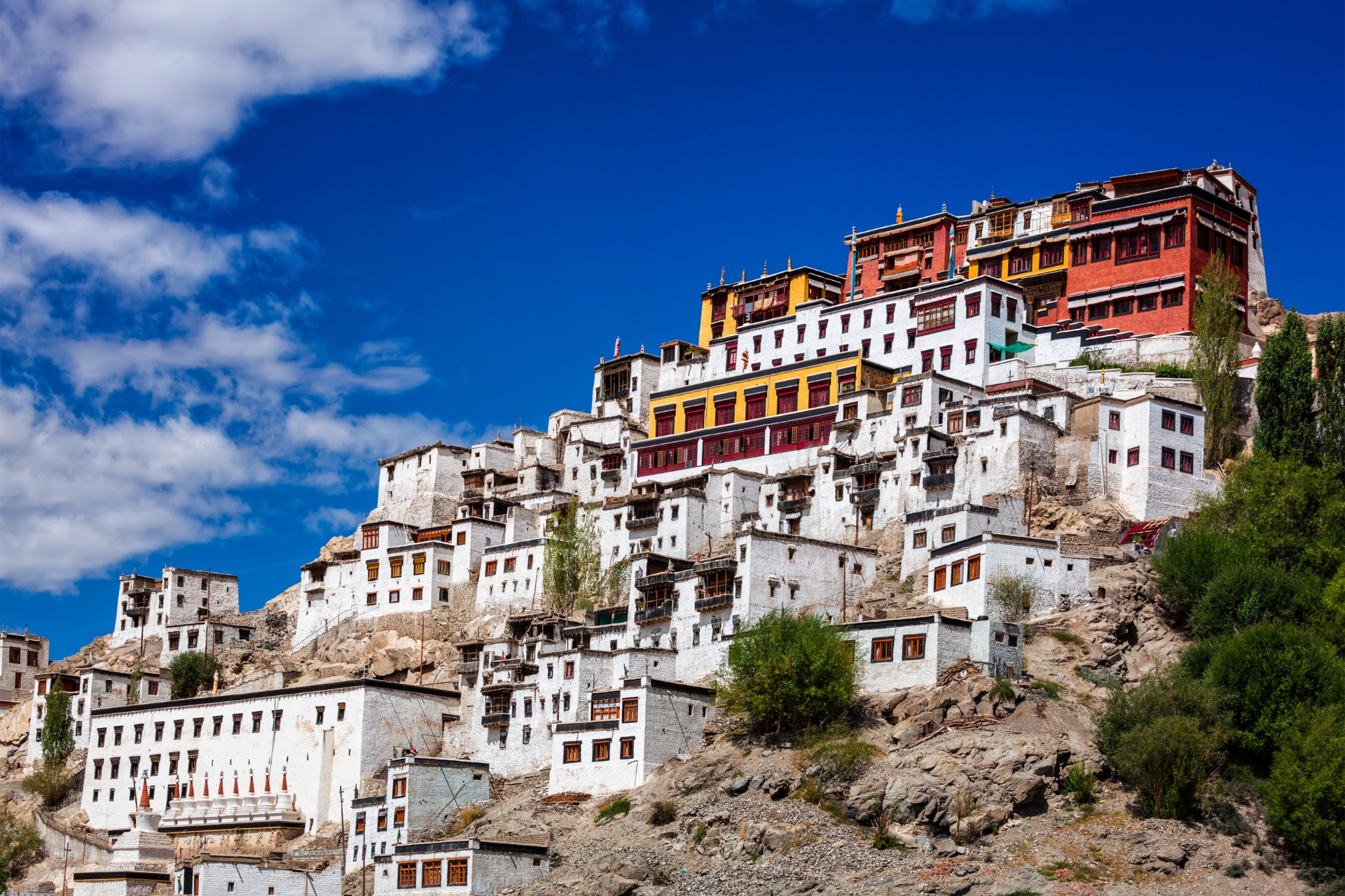
Thiksey Monastery 🙏
-
One of Ladakh’s largest and most beautiful monasteries.
-
Houses a 15-meter-high statue of Maitreya Buddha.
-
Offers mesmerizing sunrise views.
📍 Location: 20 km from Leh | ⏳ Time Needed: 1-1.5 hours
Shey Palace & Monastery 🏰
-
Former summer palace of Ladakhi kings.
-
Home to a massive golden Buddha statue.
📍 Location: 15 km from Leh | ⏳ Time Needed: 45 min
Leh Market & Tibetan Refugee Market 🛍️
-
Best place to buy souvenirs, Tibetan handicrafts, pashmina shawls, and silver jewelry.
-
Try local Ladakhi cuisine like Momos, Thukpa, and Butter Tea.
📍 Location: Leh City Center | ⏳ Time Needed: Flexible
Bonus: Nearby Excursions
If you have extra time, you can explore:
-
Hemis Monastery (famous for the Hemis Festival – 45 km from Leh)
-
Stok Palace (Royal residence with a museum – 15 km from Leh)
Best Time for Sightseeing
-
May to September – Best weather for exploration.
-
Avoid winter (Nov-Feb) due to extreme cold.
Tips for Travelers
✅ Acclimatize for a day before sightseeing (Leh is at 3,500m altitude).
✅ Carry warm clothing (weather changes rapidly).
✅ Stay hydrated and avoid alcohol on the first day.
✅ Respect local Buddhist customs in monasteries.
Leh is a blend of culture, adventure, and natural beauty, making it a must-visit destination in Ladakh!
The journey from Leh to Nubra Valley is one of the most thrilling and scenic rides in Ladakh. It takes you through Khardung La, one of the highest motorable passes in the world, and into the mesmerizing landscapes of Nubra Valley, famous for its sand dunes, Bactrian camels, and monasteries.
Distance & Duration
-
Total Distance: 120 km
-
Travel Time: 4 to 6 hours (depending on road and weather conditions)
Route & Road Conditions
-
Leh → Khardung La Pass (40 km, 1.5-2 hours)
-
Ride through steep, winding roads to reach Khardung La (5,359m).
-
Take a short break at the pass for tea and photos (avoid long stays due to low oxygen levels).
-
-
Khardung La → Khardung Village → Khalsar (50 km, 1.5-2 hours)
-
Descend towards Khardung Village, a small settlement.
-
Roads become smoother after Khardung La.
-
Reach Khalsar, a key junction where the road splits:
-
Left → Diskit & Hunder (Main Nubra Valley)
-
Right → Sumur & Panamik (Less-explored part of Nubra)
-
-
-
Khalsar → Diskit → Hunder (30 km, 1-2 hours)
-
Visit Diskit Monastery, home to the tallest Maitreya Buddha statue in Ladakh.
-
Ride further to Hunder, famous for sand dunes and double-humped camels.
-
Best Time to Travel
✅ May to September – Best road conditions and pleasant weather.
❌ October to April – Harsh winters, Khardung La may close due to snow.
Transport Options
-
Motorcycles: Royal Enfield Himalayan, KTM Adventure are ideal.
-
4x4 SUVs: Preferable for a comfortable ride.
-
Public Transport: Limited buses and shared taxis operate.
Things to Carry
✔ Warm Clothing – Khardung La is extremely cold, even in summer.
✔ Snacks & Water – Limited food options en route.
✔ Fuel – No petrol pumps after Leh, carry extra fuel if needed.
✔ Medicine for Altitude Sickness – Ride through high-altitude terrain.
Highlights Along the Way
🏔️ Khardung La Pass – One of the highest motorable roads in the world.
🙏 Diskit Monastery – 32m tall Maitreya Buddha statue.
🐫 Hunder Sand Dunes – Enjoy Bactrian camel rides.
💦 Panamik Hot Springs (if visiting Sumur side).
Tips for a Smooth Ride
✅ Start early from Leh to avoid afternoon traffic at Khardung La.
✅ Acclimatize in Leh before attempting this ride.
✅ Carry cash, as ATMs are rare in Nubra Valley.
This ride is a must-do for bikers and adventure lovers, offering an unforgettable mix of high-altitude thrill and breathtaking landscapes!
The ride from Turtuk to Siachen Base Camp is an extreme adventure, taking you through remote landscapes, high mountain passes, and military-controlled zones. This route is one of the most offbeat and challenging rides in Ladakh.
Distance & Duration
-
Total Distance: 110 km
-
Travel Time: 5 to 7 hours (depending on road and weather conditions)
Route & Road Conditions
-
Turtuk → Thoise (55 km, 2-3 hours)
-
Ride along the Shyok River, passing Bogdang and Chalunka villages.
-
Reach Thoise, a key Indian Air Force base.
-
-
Thoise → Sasoma (25 km, 1-1.5 hours)
-
The terrain becomes more rugged and isolated.
-
You’ll see Indian Army outposts along the route.
-
-
Sasoma → Siachen Base Camp (30 km, 1.5-2 hours)
-
Restricted Zone: Only Indian citizens with special permits are allowed.
-
The last stretch is high-altitude and extremely cold.
-
Reach Siachen Base Camp (3,657m) – the world’s highest battlefield.
-
Permit Requirements
✅ Indian Nationals Only – Foreigners are not allowed beyond Hunder.
✅ Inner Line Permit (ILP) – Required for Nubra Valley.
✅ Special Military Permission – Needed for Siachen; can be arranged through local travel agents or army contacts in Leh.
Best Time to Travel
✅ June to September – Roads are open and weather is manageable.
❌ October to May – Harsh winters and heavy snow make travel risky.
Transport Options
-
Motorcycles: Royal Enfield Himalayan, KTM Adventure, or 4x4 SUVs are best suited.
-
No Public Transport: This is a restricted military zone.
Things to Carry
✔ Warm Clothing & Gloves – Temperatures drop sharply.
✔ Food & Water – No civilian facilities near Siachen.
✔ Fuel – No petrol pumps; refuel at Diskit or bring extra fuel.
✔ First Aid & Oxygen Cylinder – High-altitude sickness risk.
Highlights Along the Way
🏔️ Turtuk – The Last Village of India (Rich Balti culture).
🏕️ Thoise – Important Indian Air Force base.
❄️ Siachen Base Camp – World’s highest battlefield.
Important Tips
✅ Respect Army Guidelines – Photography is restricted in some areas.
✅ Acclimatize Properly – Altitude gain is significant.
✅ Start Early – Roads are rough, and weather can change suddenly.
This ride is one of the rarest and most exhilarating experiences, taking you to the edge of adventure and patriotism!
The ride from Nubra Valley to Pangong Lake is an adventurous off-road journey, passing through Shyok Valley or Wari La Pass. This route is filled with rugged landscapes, river crossings, and stunning Himalayan views, making it a favorite among bikers and adventure seekers.
Distance & Duration
-
Via Shyok Route (Recommended)
-
Distance: 170 km
-
Travel Time: 6-7 hours
-
-
Via Wari La Route (Tougher, but scenic)
-
Distance: 250 km
-
Travel Time: 8-10 hours
-
Route Options & Road Conditions
1. Route via Shyok (Easier & Shorter Route – Recommended)
🚦 Route: Hunder/Diskit → Khalsar → Agham → Shyok → Durbuk → Tangtse → Pangong Lake
✅ Advantages:
-
Shorter & faster route.
-
Follows the Shyok River, with mesmerizing views.
-
Mostly motorable, but some stretches have rough patches & water crossings.
❌ Challenges:
-
Risk of landslides & river crossings (especially in monsoon).
-
No major fuel stations or repair shops after Diskit.
2. Route via Wari La (Difficult & Longer Route)
🚦 Route: Hunder/Diskit → Khalsar → Agham → Wari La → Sakti → Chang La → Pangong Lake
✅ Advantages:
-
Less crowded & extremely scenic.
-
Crosses Wari La (5,312m) – one of Ladakh’s toughest mountain passes.
❌ Challenges:
-
Very steep climbs & rough roads.
-
Higher altitude than the Shyok route, increasing the risk of altitude sickness.
-
Longer travel time & fewer villages for food & rest.
Best Time to Travel
✅ May to September – Best road conditions & weather.
❌ October to April – Extreme cold, snow-covered passes may be closed.
Transport Options
-
Motorcycles: Royal Enfield Himalayan, KTM Adventure, or any off-road bike.
-
4x4 SUVs: Best for comfort & handling tough terrain.
-
No Public Transport: No direct buses; taxis are expensive.
Things to Carry
✔ Warm Clothing & Rain Gear – Weather changes quickly.
✔ Fuel – Last petrol pump in Diskit; carry extra fuel.
✔ Food & Water – No major eateries on the way.
✔ First Aid & Oxygen Cylinder – High-altitude sickness risk.
Highlights Along the Way
🏜️ Shyok Valley – Stunning barren landscapes.
⛰️ Wari La & Chang La (if taking Wari La route) – High-altitude adventure.
🏞️ Pangong Lake – Crystal-clear blue waters at 4,225m altitude.
Important Tips
✅ Start Early – Road conditions are unpredictable.
✅ Check Weather & Road Updates – Landslides & river crossings can block roads.
✅ Respect Army Checkpoints – Carry ID & permits.
This ride is a dream for adventure riders, offering a perfect blend of thrill, beauty, and solitude in the Himalayas!
The ride from Pangong Lake to Hanle is a breathtaking journey through remote landscapes, high-altitude desert terrain, and restricted military zones. Hanle is home to the Hanle Observatory, one of the world’s highest astronomical observatories, and offers some of the clearest night skies in India.
Distance & Duration
-
Total Distance: 160-180 km
-
Travel Time: 6-7 hours (depending on road conditions)
Route & Road Conditions
🚦 Route: Pangong Lake → Merak → Chushul → Tsaga La → Loma → Hanle
-
Pangong Lake → Merak → Chushul (50 km, 1.5-2 hours)
-
Ride along the southern edge of Pangong Lake (off-road, rough patches).
-
Pass Merak & Chushul villages, close to the Indo-China border.
-
Chushul War Memorial – Dedicated to soldiers of the 1962 India-China War.
-
-
Chushul → Tsaga La → Loma (80 km, 3-4 hours)
-
Cross Tsaga La Pass (4,625m) – offers stunning views.
-
The road is mostly barren, remote, and military-controlled.
-
Loma Checkpost – Need to show permits before proceeding to Hanle.
-
-
Loma → Hanle (50 km, 1.5-2 hours)
-
Smooth roads after Loma, with vast open landscapes.
-
Hanle is a tiny village with an altitude of 4,500m, famous for its observatory and breathtaking night skies.
-
Permit Requirements
✅ Indian Nationals Only – Foreigners need special permits from Leh DC office.
✅ Inner Line Permit (ILP) – Required for Pangong, Chushul, Tsaga, and Hanle.
✅ Special Permission from Army – Sometimes required at Chushul & Loma.
Best Time to Travel
✅ May to September – Roads are open and weather is favorable.
❌ October to April – Extreme cold, high-altitude snow, and blocked routes.
Transport Options
-
Motorcycles: Royal Enfield Himalayan, KTM Adventure, or any off-road bike.
-
4x4 SUVs: Ideal for rough terrain & comfort.
-
No Public Transport: No buses; only private vehicles allowed.
Things to Carry
✔ Warm Clothing – Nights are freezing even in summer.
✔ Fuel – Last fuel station is in Karu or Diskit, carry extra fuel.
✔ Food & Water – No major restaurants; only homestays in Hanle.
✔ First Aid & Oxygen Cylinder – Risk of altitude sickness.
Highlights Along the Way
🌊 Pangong Lake – Ride along its beautiful shores.
🏔️ Tsaga La Pass – Panoramic Himalayan views.
🌌 Hanle Observatory – India’s highest & best spot for stargazing.
Important Tips
✅ Start Early – No streetlights, and riding after dark is dangerous.
✅ Check Weather & Road Updates – Military zones can have sudden restrictions.
✅ Respect Army Checkpoints – Always carry permits & ID proofs.
This ride is a once-in-a-lifetime experience, offering surreal landscapes and a chance to witness the Milky Way in its full glory at Hanle!
The ride from Hanle to Tso Kar is a surreal journey through high-altitude desert landscapes, remote valleys, and rugged roads. Tso Kar, also known as the "White Lake", is one of Ladakh’s most stunning yet lesser-explored saltwater lakes, famous for its wildlife, birdwatching, and isolated beauty.
Distance & Duration
-
Total Distance: 150-160 km
-
Travel Time: 5-6 hours (depending on road conditions)
Route & Road Conditions
🚦 Route: Hanle → Loma → Nyoma → Mahe → Puga → Tso Kar
-
Hanle → Loma → Nyoma (50 km, 1.5-2 hours)
-
Start from Hanle Observatory and ride towards Loma Checkpost (permits required).
-
Reach Nyoma, a small town with basic shops and a few homestays.
-
-
Nyoma → Mahe → Puga Valley (70 km, 2-3 hours)
-
Cross Mahe Bridge, where you’ll need to show permits again.
-
Pass through Puga Valley, known for its hot springs and geothermal activity.
-
Roads are mostly smooth, but some sections are gravel or under construction.
-
-
Puga → Tso Kar (30-40 km, 1-1.5 hours)
-
The last stretch is mostly off-road and bumpy, but the views are breathtaking.
-
As you approach Tso Kar, the lake’s white salt deposits and changing water colors create a magical scene.
-
Permit Requirements
✅ Inner Line Permit (ILP) – Required for Hanle, Nyoma, Mahe, and Tso Kar.
✅ Special Permission from Army – Sometimes required at Loma Checkpost.
Best Time to Travel
✅ May to September – Best weather and road conditions.
❌ October to April – Extreme cold, frozen lakes, and harsh travel conditions.
Transport Options
-
Motorcycles: Royal Enfield Himalayan, KTM Adventure, or off-road bikes.
-
4x4 SUVs: Ideal for rough patches and high-altitude driving.
-
No Public Transport: No buses, only private vehicles allowed.
Things to Carry
✔ Warm Clothing – Nights are extremely cold, even in summer.
✔ Fuel – Last fuel station in Karu or Nyoma, carry extra fuel.
✔ Food & Water – No major restaurants, only basic homestays.
✔ First Aid & Oxygen Cylinder – High-altitude sickness risk.
Highlights Along the Way
🌄 Puga Valley – Natural hot springs and sulfur deposits.
🦩 Tso Kar Lake – Home to rare migratory birds, including black-necked cranes.
🏔️ Himalayan Landscape – Remote, untouched beauty all around.
Important Tips
✅ Start Early – Limited daylight and no streetlights.
✅ Check Weather & Road Updates – Remote routes can change quickly.
✅ Respect Wildlife & Local Communities – Tso Kar is an important wildlife area.
This ride is a dream for adventure lovers, offering a mix of solitude, breathtaking landscapes, and unforgettable high-altitude beauty!
The ride from Tso Kar to Manali is a long but spectacular journey through rugged mountain passes, high-altitude deserts, and lush green valleys. This route is a mix of smooth highways, off-road tracks, and challenging terrain, making it a thrilling ride for adventure seekers.
Distance & Duration
-
Total Distance: 230-250 km
-
Travel Time: 8-10 hours (depending on road and weather conditions)
Route & Road Conditions
🚦 Route: Tso Kar → Debring → More Plains → Pang → Sarchu → Baralacha La → Jispa → Keylong → Rohtang Pass → Manali
-
Tso Kar → Debring → More Plains (40 km, 1-1.5 hours)
-
Start from Tso Kar Lake, riding through gravel roads towards Debring.
-
Enter the More Plains, a beautiful, flat stretch of road at 4,800m altitude.
-
The road here is mostly smooth, but strong winds and sandstorms are common.
-
-
More Plains → Pang → Sarchu (80 km, 2-3 hours)
-
Ride down towards Pang, a popular stop for bikers with small roadside dhabas (food stalls).
-
Cross Gata Loops (21 hairpin bends) – an exciting yet challenging section of the ride.
-
Reach Sarchu, the border between Ladakh and Himachal Pradesh.
-
-
Sarchu → Baralacha La → Jispa (90 km, 3-4 hours)
-
Cross Baralacha La Pass (4,890m), often covered with snow.
-
Ride past Suraj Tal, a beautiful high-altitude lake.
-
Descend towards Jispa, where the terrain starts turning greener.
-
-
Jispa → Keylong → Rohtang Pass → Manali (90 km, 3-4 hours)
-
Ride through Keylong, the last big town before Manali.
-
Cross the mighty Rohtang Pass (3,978m) – expect fog, rain, or even snow.
-
Descend into the lush green Kullu Valley and reach Manali.
-
Best Time to Travel
✅ June to September – Roads are open and weather is favorable.
❌ October to May – Heavy snow blocks Baralacha La & Rohtang Pass.
Transport Options
-
Motorcycles: Royal Enfield Himalayan, KTM Adventure, or off-road bikes.
-
4x4 SUVs: Best for comfort and handling tough terrain.
-
Public Transport: Limited buses/taxis operate on this route.
Things to Carry
✔ Warm Clothing & Rain Gear – Weather changes suddenly.
✔ Fuel – Last fuel pump in Keylong, carry extra fuel.
✔ Food & Water – Limited food options after Sarchu.
✔ First Aid & Oxygen Cylinder – High-altitude sickness is common.
Highlights Along the Way
🏜️ More Plains – One of the most beautiful stretches in Ladakh.
🚵 Gata Loops – 21 thrilling hairpin bends.
🏔️ Baralacha La Pass – A challenging high-altitude pass.
💚 Rohtang Pass – The gateway to lush green Manali.
Important Tips
✅ Start Early – This is a long ride with tough terrains.
✅ Check Weather & Road Updates – High passes can close due to landslides.
✅ Ride Safely – Some sections have gravel, river crossings, and slippery roads.
This ride is a perfect mix of adventure, beauty, and endurance, making it one of the most epic journeys in the Himalayas!
The journey from Manali to Chandigarh marks the end of an unforgettable Himalayan adventure. This ride takes you from the serene valleys of Himachal Pradesh to the urban landscapes of Chandigarh, passing through winding mountain roads, lush forests, and scenic river valleys.
Distance & Duration
-
Total Distance: 290-310 km
-
Travel Time: 8-10 hours (depending on road conditions & traffic)
Route & Road Conditions
🚦 Route: Manali → Kullu → Mandi → Bilaspur → Kiratpur Sahib → Chandigarh
-
Manali → Kullu → Mandi (100 km, 3-4 hours)
-
Start early to avoid traffic on the Manali–Kullu highway.
-
Ride along the Beas River, passing apple orchards and small villages.
-
Cross Pandoh Dam and enter Mandi, the gateway to lower Himachal.
-
-
Mandi → Bilaspur (70 km, 2-3 hours)
-
The road here has sharp curves and descending slopes.
-
Pass through Sundernagar, known for its peaceful lake.
-
Bilaspur offers beautiful views of the Gobind Sagar Lake.
-
-
Bilaspur → Kiratpur Sahib → Chandigarh (120 km, 3-4 hours)
-
After Bilaspur, the road becomes wider and smoother.
-
Cross Kiratpur Sahib, a famous Sikh pilgrimage site.
-
Enter Punjab, where the terrain becomes flat and highway riding begins.
-
Reach Chandigarh, completing your epic Himalayan journey.
-
Best Time to Travel
✅ March to November – Pleasant weather & good road conditions.
❌ December to February – Winter snow in Manali can delay travel.
Transport Options
-
Motorcycles: Royal Enfield Himalayan, KTM Adventure, or any touring bike.
-
Private Car/Taxi: Best for a relaxed journey.
-
Buses: Frequent Volvo & state-run buses available from Manali to Chandigarh.
Things to Carry
✔ Riding Gear & Helmet – For safety on highways.
✔ Snacks & Water – Limited good restaurants on the way.
✔ Raincoat/Poncho – Sudden rain showers are common.
✔ Cash & Fuel – Fuel up in Mandi or Bilaspur as petrol pumps are sparse.
Highlights Along the Way
🏞️ Pandoh Dam – Scenic river views.
💦 Gobind Sagar Lake – A peaceful reservoir in Bilaspur.
🚗 Kiratpur Sahib – A historic Sikh pilgrimage site.
🌿 Smooth Highways – Enjoy a comfortable ride in the final stretch.
Important Tips
✅ Start Early – To avoid heavy traffic in Mandi & Bilaspur.
✅ Drive Carefully – Curvy roads & steep descents in Himachal.
✅ Check Weather Conditions – Monsoon can cause landslides near Mandi.
This final stretch is a smooth yet nostalgic ride, marking the end of an epic road trip through the Himalayas!
Cost
Includes
- Accommodation on Twin/Triple sharing basis in 3* Segment property.
- Meals : Dinner & Breakfast (11 Breakfast & 11 Dinner).
- Wildlife & Environment fee.
- GST Included 18%.
- Experienced and friendly trip leader, 24*7 onboard assistance.
- Local support in case of any emergency.
- Oxygen can and medical kit to handle extreme situations.
- Basic Medical & Mechanical Support.
- Parking Facilities.
- Back-up vehicle Leh to Leh.
- Sukoon Expedia Goodies & Merchandises.
Excludes
- Lunch throughout the trip.
- Fuel throughout the trip.
- Toll Taxes.
- Cost of any spare parts consumed during the ride.
- Purchase of any personal items & activities.
- Packaged mineral water during the ride.
- Any emergency or unexpected expense that may arise during the ride due to a natural calamity or mishap.
- Anything not mentioned in tour inclusions.
FAQs
The best time for a bike ride in Ladakh and Himachal Pradesh is June to September. During this period, the roads are open, the weather is pleasant, and the mountain passes are accessible. Avoid riding in winter (October to April) due to heavy snowfall and road closures.
Yes, certain areas require special permits:
-
Inner Line Permit (ILP) – Required for Pangong Lake, Nubra Valley, Tso Moriri, Hanle, and Tso Kar.
-
Protected Area Permit (PAP) – Required for foreign nationals traveling to restricted zones.
-
Rohtang Pass Permit – Required if traveling from Manali to Leh (not needed for return).
Permits can be obtained online or from the Leh DC Office.
The best bikes for this journey are:
-
Royal Enfield Himalayan / Classic 350 / Bullet 500 – Ideal for rough terrains.
-
KTM Adventure 390 – Lightweight and good for off-roading.
-
Hero Xpulse 200 – Budget-friendly and off-road capable.
Ensure your bike is well-serviced, and carry spare parts, puncture kits, and extra fuel.
Follow these tips to avoid Acute Mountain Sickness (AMS):
-
Acclimatize properly – Spend at least 1-2 days in Leh before heading to higher altitudes.
-
Stay hydrated – Drink plenty of water and avoid alcohol.
-
Ride slowly & take breaks – Avoid rapid altitude gain.
-
Carry Diamox (if needed) – Helps with altitude sickness (consult a doctor before use).
Fuel stations are limited in Ladakh and Spiti. Here are key locations to refuel:
-
Manali, Keylong, Tandi (last pump before Leh on Manali-Leh Highway)
-
Leh, Diskit (Nubra Valley), Karu, Nyoma (for Hanle & Tso Moriri)
-
Carry extra fuel in jerry cans for remote areas like Hanle, Pangong, and Tso Kar.
Limited network coverage in Ladakh & Spiti:
-
Good Coverage – Chandigarh, Manali, Leh, Keylong, and Kargil (Jio, Airtel, and BSNL).
-
Weak/No Coverage – Nubra Valley, Pangong, Hanle, Sarchu, Tso Moriri, and Tso Kar.
-
Only Postpaid SIMs Work in Ladakh – Prepaid SIMs from other states will not work due to security regulations.
✅ Tip: Carry a BSNL postpaid SIM for better coverage in remote areas.
The roads vary from smooth highways to rough off-road trails. Expect:
-
Good Roads – Chandigarh to Manali, More Plains, and some sections of the Leh-Manali Highway.
-
Bad Roads – Baralacha La, Chang La, Pangong to Hanle, and some parts of Spiti Valley.
-
River Crossings – Common near Sarchu, Zing Zing Bar, and during monsoons.
-
Landslides & Snowfall – Possible in Rohtang Pass, Baralacha La, and Khardung La, especially during early and late seasons.
Fuel is more expensive in remote areas due to transportation costs. Approximate fuel prices:
-
Chandigarh/Manali – ₹100-110 per liter
-
Leh – ₹120-130 per liter
-
Tandi (last fuel station before Leh on Manali-Leh route) – ₹140-150 per liter
-
Diskit/Nubra Valley – ₹130-140 per liter
-
Hanle/Tso Moriri (black market fuel) – ₹150-200 per liter
✅ Tip: Always refuel at Keylong/Tandi before heading to Ladakh, and carry extra fuel for remote routes like Hanle & Tso Kar.


